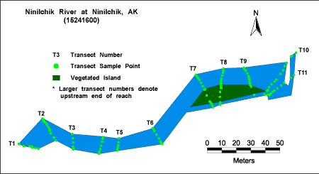
Ninilchik River at Ninilchik
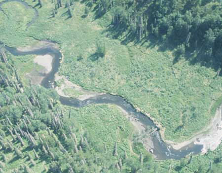
Aerial view looking south of the Ninilchik River NAWQA ecology reach upstream of the Sterling Highway Bridge. Downstream is to the right.
Habitat Photo Image Map
Click on a transect number to see habitat photos for that transect.
Site Information
NAWQA REACH
Prepared by: F.O. Morris 04-15-63
Revised by: B.A. Swenson 12-30-99
LOCATION.---Lat 60× 02’56”, long 151× 39’x48”, NE 1/4 sec. 34, T. 1S., R. 14 W. (Kenai A-5 quad), Hydrologic Unit 19020301, on right bank 60 ft. downstream of bridge, 0.1 miles southeast of Ninilchik, and 0.9 miles upstream from mouth .
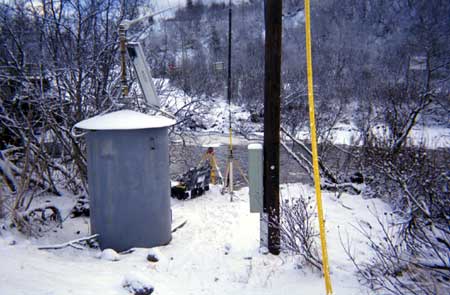
ESTABLISHMENT AND HISTORY.--Two wire-weight gages were operated concurrently on Ninilchik Road bridge and Sterling Highway bridge from April 15, 1963 to October 9, 1965. Reestablished as a recording station November 8, 1966 to August 15, 1967. On September 3, 1967 the type-A wire-weight was reestablished on a new wooden bridge at the same site and datum. The bridge was damaged by ice in May 1972 and was removed and replaced by a steel girder bridge with no center support. The wire-weight gage was reestablished June 13, 1973 at approximately the same location and datum and operated through the 1985 water year. The wire-weight gage was reestablished on September 29, 1998 at approximately the same location and datum, but since the orifice is considerably downstream from the wire-weight a series of reference points (tape-ups from steel pins supporting orifice cable) are used as the reference gage.
DRAINAGE AREA.--131 mi2.
EQUIPMENT.-- Sutron 8200 data collection platform (DCP), Accubar pressure sensor and Therm-X thermistor were installed September 29, 1998.
REFERENCE AND BENCH MARKS.--RM-9 (base) is chiseled square on top of large rock 30 ft. east and 44 ft. south of left bank downstream corner of bridge. Elevation is 8.595 ft., gage datum (levels of September 29, 1998). RP-11 thru 14 were established September 29, 1998 and are used as reference elevation for the gage. RM-10 is top of vertical 3/8 inch lag bolt on top of downstream end of right bank head-wall. Elevation is 15.72 ft., gage datum. Established June 13, 1972. RP-11 is the farthest shoreward steel pin supporting orifice cable. Elevation is 3.91 ft., gage datum. (levels of July 6, 1999) RP-12 is steel pin supporting orifice cable. Elevation is 3.71 ft., gage datum. (levels of July 6, 1999) RP-13 is steel pin supporting orifice cable. Elevation is 3.65 ft., gage datum. (levels of July 6, 1999) RP-14 is farthest streamward steel pin supporting orifice cable. Elevation is 3.60 ft., gage datum. (levels of Sept. 29, 1998)
CHANNEL AND CONTROL.--Channel is braided for 100 ft. above the bridge and straight for 100 ft. below the gage. Streambed is composed of gravel and cobble. Flow is confined to one channel below gage. Control is rock-riffles 50 to 100 ft. below gage at low and medium stages and channel control at high stages.
DISCHARGE MEASUREMENTS.--Current-meter measurements at low and medium stage are made by wading at the gage. High-water measurements are made from bridge. Discharge measurements made during ice cover are made at gage. WINTER FLOW.--Stage-discharge relation will be effected by ice.
POINT OF ZERO FLOW.--Variable.
REGULATION AND DIVERSION.---None.
ACCURACY.--Records will be good except for periods of ice effect, which will be poor.
COOPERATION.--
PURPOSE.--Provide streamflow and water-quality data for the Cook Inlet NAWQA.
ROAD LOG.-- mi. e Description 0 From Anchorage go south on Seward Hwy to Sterling Hwy exit. 80 Go right on Sterling Hwy exit towards Soldotna. 90 Go right after crossing the Ninilchik R. towards the Ninilchik State Rec. Area. 0.2 Go right to villiage of Ninilchik. 0.1 Cross the Ninilchik R. and turn left into parking area next to gage house on right bank.
Surface Water
GAGING STATION